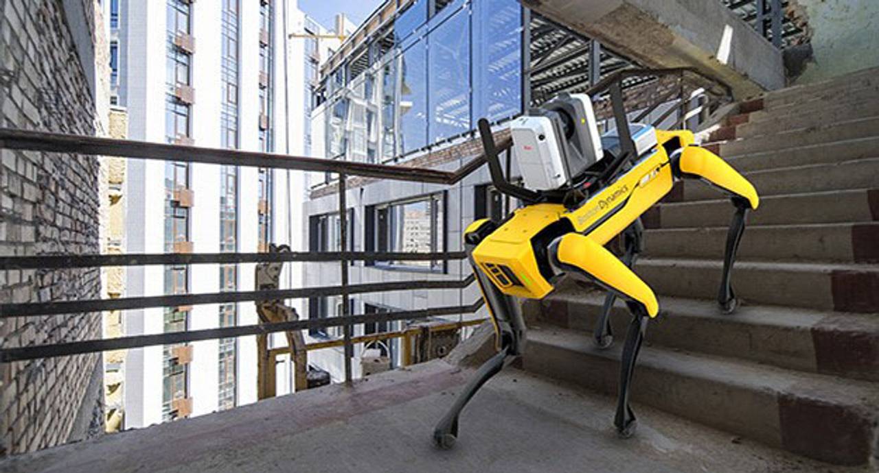
Leica Geosystems has introduced its reality capture solution for a variety of industries, including construction. By combining Boston Dynamics’ agile mobile robot, Spot, with the Leica RTC360 3D laser scanner, scanning time spent by human operators can be significantly reduced - by programming the devices to repeat automated scanning paths through sites.
“This requires minimal monitoring by the user, allowing for increased scanning efficiency, productivity, and flexibility when planning reality capture tasks,” said Leica Geosystems. Professionals in many different industries with autonomous scanning needs, such as construction, can benefit from programmed scanning tasks, especially for locations that must be repeatedly scanned for up-to-date digital twins.
The company highlighted that “whenever accurate, reliable, and up-to-date 3D data is needed, the integration of Leica Geosystems' RTC360 technology onto the Spot mobile robot provides significant additional customer value in a variety of industries and jobsite scenarios where flexible and agile laser scanning workflows are required. Spot’s ability to cover many types of terrain and the RTC360's VIS (Visual Inertial System) creates this solution.”
While mounted atop Spot, the Leica RTC360’s VIS technology uses five cameras to track the scanner's movement within the site between the scans, explained Leica Geosystems. The VIS system provides an unmatched level of accurate and automated in-field pre-registration to streamline the reality capture process. During scanning, the user only needs to trigger each scan remotely via mobile device while Spot and the RTC360 navigate the programmed scanning path.
“The RTC360's VIS technology creates an easier, faster scanning workflow,” said Leica Geosystems. “For example, users can essentially ‘walk’ Spot through a site by using a mobile device to control the RTC360 scanner. This allows users to speed up routine as-built documentation tasks and capture data accurately, quickly, and frequently. It also automatically combines captured scan data from station to station as it knows its location in space, resulting in a completely pre-registered point cloud of the entire scanned site, which makes final data processing in the office much easier.”
“Making the RTC360 and VIS technology available on Spot is a great step forward from Leica Geosystems to provide autonomous reality capture solutions,” said Thomas Harring, CEO of Leica Geosystems. “Customers benefit from the user-friendly combination of both devices, our relationships with leading technology experts enable us to accelerate our delivery of these technologies while addressing the growing need for autonomy, automation of construction processes, and precision in 3D scanning.”
Leica Geosystems reiterated that “combining Spot with the RTC360 creates a mobile scanning solution that saves time, because Spot does the walking and stationing of individual scans instead of the user. Once Spot and the RTC360 learn a programmed scanning route through a location, they can more easily and quickly repeat that route for regular scanning. The remote control of the Leica RTC360 via a mobile device allows Spot's agility and mobility to cover terrain that may be difficult or hazardous for a human operator.”
The new Leica RTC360 for Spot includes all needed installation accessories, a protection bar for the scanner cameras, and Leica Geosystems software ensuring that users can get started within minutes. The RTC360 installation kit for Spot is available through Leica Geosystems distribution channels and Spot through Boston Dynamics.